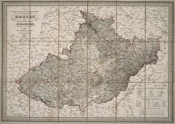
Neueste General-, Post- u. Strassenkarte der Markgrafschaft Mähren
19th / 20th century
Castle Museum in Łańcut
Part of the collection: Cartography
Tourism has an incredibly long history. The subject of this description is a tourist map of India from 1929. The map was drawn based on the findings, measurements and studies of the Surveyor General of India, Henry R. Thomas. In 1858–1947, India was part of a larger protectorate called British India. It consisted of the territories of present day India, Pakistan, Nepal, Bangladesh, Sri Lanka, parts of Bhutan and Myanmar. This protectorate was headed by a viceroy. The map was published by Sifton, Praed & Company Limited, founded by Alfred Sifton and Francis Praed in 1907. The point of sale for the maps was (and still is) a shop called “The Map House”. It was originally called Map and Booksellers and sold new maps as well as those of antiquarian value. It marketed to collectors, drivers, pilots, explorers and Prime Ministers of governments, including British PM Winston Churchill. Interestingly, the company also sold maps to members of the royal family. Throughout their history, they have furnished the British Library in London and the Library of Congress in Washington, DC, with the relevant maps. The map depicts the area of present-day India including the administrative divisions of the time. The most important cities, roads and railways have been marked on the map. Łukasz Chrobak
Author / creator
Object type
Cartography
Technique
Material
paper
Owner
Castle Museum in Łańcut
Identification number
Location / status

19th / 20th century
Castle Museum in Łańcut

20th century
Castle Museum in Łańcut

1826
Castle Museum in Łańcut
DISCOVER this TOPIC
Museum of King Jan III's Palace at Wilanów
DISCOVER this PATH
Educational path