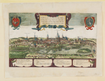
View of Lublin (Tipus civitatis Lublinensis In Regno Poloniae…)
1618
National Museum in Lublin
Part of the collection: Lubliniana. Painting views of Lublin and the Lublin Region (17th–early 20th c.)
The view is out of the album of Gabriel Bodenehr the Elder Curioses Staats und Kriegs Theatrum in Polen, durch unterschiedliche Geographische, Topographische und Historische Land-Carten, Grundrisse und Prospect, Erläutert, published in Augsburg around 1730. The work includes views and plans of Polish cities made in copperplate in the years 1710-1730. There are two coloured maps of Poland, a family tree of Polish rulers from the times of Mieszko to Stanisław Leszczyński, and views of Kraków, Warsaw, Piotrków Trybunalski, Kamieniec Podolski, Vilnius, Grodno, Lublin, Zamość, Jasna Góra, Elbląg, Królewiec, Toruń, Gdańsk, the Wisłoujście fortress and the plans of Poznań, Warsaw, Brest, Krzyżtopor and Malbork.
The panorama of Lublin included in Bodenehr’s album is a replication of Braun and Hogenberg’s engravings presented in Civitates Orbis Terrarum (1618). It unfolds, and was printed from two plates, with its height significantly reduced compared to the original. It differs from the Hogenberg / Braun panorama in details. Above the towers of the Jesuit Church and the Kraków Gate is a ribbon with the inscription: LUBLIN In Pohlen. On the sides, in places of the heraldic cartouches, there are small ‘floating’ askew shields. In the lower part, two rectangular fields were introduced, covering part of the foreground of the composition, containing information about Lublin and a legend in German.
The figure does not show how Lublin looked at that time. The actual view of the city in the beginning of the 18th century is depicted in the monumental oil painting The Fire of the City of Lublin in 1719, painted around 1740 by an unknown painter, and currently kept at the Dominican church in Lublin. The painting shows a modern city with Renaissance and Baroque architecture, reconstructed after the destruction and plunder caused by the wars of the 2nd half of the 17th century, including the Swedish Deluge. Its course is described in a commentary on Bodenehr’s engraving, which also includes information about the location and population of the city.
The publisher and co-author of the drawing, Gabriel Bodenehr the Elder, a German chalcographer and cartographer, was one of the most important publishers in Augsburg. His most famous work is the Atlas curieux containing various views and city maps, published since 1704 in volumes devoted to subsequent European regions.
Renata Bartnik
Author / creator
Dimensions
cały obiekt: height: 50,2 cm, width: 16,5 cm
Object type
graphics
Technique
copper engraving
Material
ribber paper
Creation time / dating
Creation / finding place
Owner
The National Museum in Lublin
Identification number
Location / status

1618
National Museum in Lublin

1918 — 1919
National Museum in Lublin

circa 1577
National Museum in Szczecin
DISCOVER this TOPIC
Museum of King Jan III's Palace at Wilanów
DISCOVER this PATH
Educational path